Marine GPS Navigation - Everything You Should Know
Nautical GPS systems have undergone a significant change since the day they were first introduced in the market. While the early models were pretty complex and not so reliable, today, you need not be an expert of the seas to be able to use one properly. The marine technology in GPS marine navigation systems is only getting better every year. You will find more and more advanced, multifunctional units around, bringing many more interesting features and more power to you!
But has this evolution of technology made them more practical navigation equipment when you are in the middle of water faced with the sun, salt, and some spray?
Probably only if you have got your boat geared up for everything!
So before you spend hundreds or thousands of dollars on your next best GPS marine navigation system, it is advised to first get a complete understanding of what it actually is, what are its components, what all parts do, and of course, why you might need one while traveling to distant waters.
The market is flooded with different GPS systems, ranging from basic GPS, fishfinders, and transducers to GPS chartplotters, domes & arrays, Black Box modules, and more. This often makes it difficult to know what’s best for your purpose.
In this post, we will discuss everything about a Global Positioning System (GPS) in detail to help you sail with safety and confidence no matter if it’s for recreational purpose or you are a commercial mariner. Why not take a detailed look at what all the GPS navigation system holds for you!

What is a GPS Marine Navigation System?
The term GPS is an abbreviation used for Global Positioning System and a marine GPS is specifically designed for the marine environment and people involved. These systems are strongly recommended given the high level of safety they offer to the navigators of open waters. Even better, sailing courses these days, including the use of GPS systems inside the training courses too!
The majority of the GPS marine navigation systems in the market are normally handheld, and then you get the chartplotter devices and computers connected to a GPS. these units use satellites to record the speed and direction of the boat/ship which is then shown on the screen of the instrument. A chartplotter device together with a GPS system allows the ship's course to be plotted electronically.
When you are out on the water and dealing with difficulties or you are at risk, a reliable GPS unit like Garmin GPS, Lowrance GPS, FURUNO GPS, and more can help you signal the ship's position to the rescue team so they come to know where to find you. The older models of GPS systems might be deprived of this option; however, the new models by the big brands most likely have this feature for added safety.
A GPS marine navigation system normally comes with inbuilt alarms. These alarms make a sound when you were to go off course or your anchor drags all of a sudden. The marine alarms are not too loud and as the sea can be noisy itself in the rough waters, you may prefer to get yourself a GPS navigation system that could easily be connected to an external alarm on the same boat.
Now that you have a brief overview of a GPS navigation system, let’s take a look at all the devices available to you.
Handheld Units
Though units come at the cheapest prices out all the devices, they are usually pretty much accurate. Given it is called handheld, it can be used in different situations, for example, when you are above the boat, on the shore, etc. a handheld unit can be a little difficult to use due to the often small buttons. This becomes worse when you’re dealing with rough waters; however, most of these units come with mounting brackets. At times, the signal might be weaker on these devices, so it is better to invest on a model that enables you to use an external antenna.
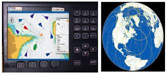
Chartplotters
In comparison to the handheld units, the chartplotters are a vast improvement both in terms of technology and performance. This type of GPS marine navigation shows the info overlaid on nautical charts. It will be the primary navigation equipment and while it’s not a complete replacement for paper charts, it does have a large screen, and the buttons are not way too bigger than the handheld devices. A chartplotter should be mounted to a fixed surface, and they generally come with external antennas. This makes placement not a big issue even for the novices. The screen sizes of different chartplotters may vary ranging between 5-10 inches. In short, you need to pay more to have a bigger and color display. The majority of chartplotters comes integrated with a GPS receiver, implying they are both included in one unit. Models like Garmin GPSMAP 7607 Sail Plus Pack, Raymarine e125 Multifunction Display, Humminbird HELIX 7 CHIRP MEGA DI and more are a few examples of the best-selling units in this category.
Computer Connected To GPS
You can use a computer with multiple types of GPS, including Sensor, Standard GPS Receiver, or a Chartplotter. The computers are generally used below the deck as the screens are rarely visible in direct sunlight. One of the many benefits of using GPS marine navigation with a computer is all the planning and navigation is managed on one unit. In some cases, a computer is a more effective solution in comparison to a chartplotter. It implies there are more software choices & 3D display apps that can also be run. There are some computers & laptops specifically made keeping in mind the marine environment!
So these are the three main choices you can consider when you are planning to purchase a new GPS marine navigation system. No matter how many options you have, it will come down to your personal preference, budget, and specific needs apart from what features you want. What we suggest is, you don’t have to cross your budget for features that you won’t probably need.
Comments
Post a Comment